Hardings Beach, Salt Pond, Long Island, Bahamas - The Beaches of Long Island
The Beaches of Long Island
The Beaches of Long Island
Hardings Beach, Salt Pond, Long Island, Bahamas
Near North > Greater Salt Pond > Salt Pond
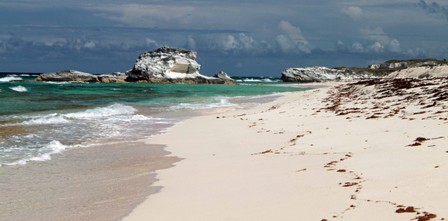
northern end, Hardings beach, Salt Pond, Long Island, Bahamas

At the entrance to Harding's Beach looking north (left) and south (right)
DIRECTIONS: Another easy one. In Salt Pond, turn onto the paved road next to the now closed Harding’s grocery store and across from the dock. As soon as you cross the ridge the road goes to sand (do you detect a theme?). At the bottom the road goes between Crystal Lake to the north and the great Carmichael Pond to the south and the road divides. Go straight to get to the Hardings. Right will take you to the ‘amphitheaters’, south Salt Pond beaches and Whelks Cay (more on those later).No
Note that the Salt Pond locals call this Carlton beach. Certainly Hardings grocery store, even though closed, is still a better island wide name and landmark, so I'll stick with calling it Hardings.
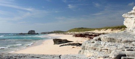
From the main entrance to Harding’s, there is about 850' of sand to the north and 1350' to the south, with the latter having a wonderful little cay roughly 800' down beach. The water between the cay and beach and between the cay and the amphitheater should provide for nice swimming and snorkeling. For the photographer, this beach has a wonderful mixture of elements to make for some dramatic photos.
The far northern end of the beach will put you under the promontory that separates Harding's from Crystal Lake. Wave action has cut out a grotto in the face of the cliff. Be careful if you go exploring in it. These rocks can be unstable, so exercise caution. The far southern end will put you at the promontory that separates Hardings from the Amphitheaters and the other Salt Pond beaches further south. The trek across this promotory isn't too difficult and makes for a nice walking/hiking/exploring circuit for those staying in Salt Pond itself.
southern end, Hardings beach, Salt Pond, Long Island, Bahamas
Looking down on the southern end
Far nothern end looking south
